

This hut trek was a part of a longer organized trip in July of 2001. During the first week we made day hikes from the camp site in Mittenwald (Germany). I am reviewing this trip using my old trip diary that I kept during the hike. I’m not sure about the state of the trail at this moment even though I was back at the Solsteinhaus in 2013. The hut was modernized and it was a very warm welcome out there. The paths seemed to be under constant observation and very popular, so my guess is that the route is still fine now.
Weather
This trip was undertaken, as a said before, in July. What I still remember from that trip is that we encountered quite a few snow fields where just a regular path should have been. We had a route description where none of the snow was mentioned. It was a winter with a lot of snow and the melting took longer than usual. Besides all the snow I gather from the diary that we had many days with beautiful mornings and early afternoons with fairly high temperatures, but mist and rain in the later afternoon. So also in this area it’s advisable during summer season to be aware of thunder storm predictions, and make sure what to do when you end up in one. Ask for weather reports in every hut you are staying in. In 2013 we were strongly advised to head back down because of snow predictions. I’m Very glad we took the advice because the next day we woke up in the valley with a 50 cm layer of fresh snow.
Marking of the route
Not sure about the quality of the markings. I do gather from old pictures of myself and pictures I saw on the internet that every junction has a sign with the different destinations and the time that it should take you to get there.
Food
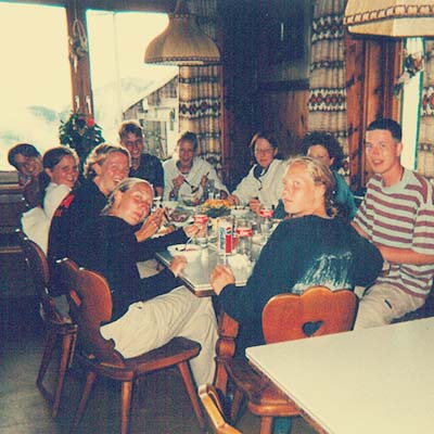 Reading back my personal report I gather that most nights we had some pasta meal, high on carbs. We also had breakfasts at the huts. I think we brought along our lunches from town and halfway through the trip we went to town to buy some more.
Water
As far as I can recall every hut has drinkable water from the tap. No need to worry about treating you water. Every very long day offers a possibility to refill your supply half way through the day.
Reservations
Always make reservations for all of the huts, to let them know how much people they have to expect every evening. They make sure there is enough food, and a bed for every person. In case you change plan due to various issues a hut will always take you in, no matter how full it is. You might end up on a mattress in the hallway, but you will be dry and warm enough. It might occur that you have to change plans due to weather or sickness, ask the host of the hut you are staying in to call ahead to all other reserved huts, so they won’t have to worry about you.
Flora and fauna
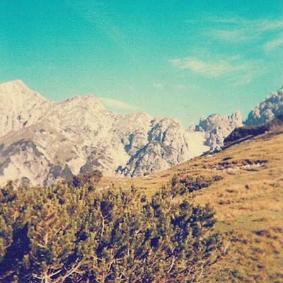
The route varies in height a lot, therefore, during one day you’ll be walking through complete bare areas with loads of rock and just a few small herbs and only a few hours later you can be in the forest. The biggest amount of the paths are through fields full with flowers, an amazing sight if you’re early enough in season. These flowers bring a wide variety of insects out too. As for other wildlife, we saw an ibex one day, and the route passed through quite a few pastures with cows in it.
Day 1 Gießenbach (Scharnitz, Austria) – Solsteinhaus
6 hours – 1150 m ascent, 300 m descent
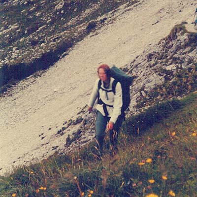
You can take the train to Gießenbach (964 m) or park your car for free close to the rail crossing. The first stage of the hike is fairly easy going over an unpaved road up to the Eppzirler Alm (1459 m). From the Alm the path changes over, it becomes narrow. The path crosses a few rock slides here and there. The last part of the climb to the Eppzirler Scharte (2102 m) is steep and winding. The first part of the descent is pretty much the same condition, switching over in a scree path. You can compare walking this part with walking in snow on a steep slope, every step is a big slide. The Solsteinhaus (1805 m) will come into view only at the last moment.
Day 2 Solsteinhaus – Pfeishütte
8 hours – 1100 m ascent, 1000 m descent
From the Solsteinhaus (1805 m) you follow the 16/213 down towards the Grosses Kristental. As soon as you end up at a couple of bifurcations keep to the right as much as possible towards the Gipfelstürmerweg. From this point on you’ll climb to an altitude of 1900 m.
From this point on you can choose between two different routes. The one I’ll describe is the easier one of the two, making a deep descent. The other option you can find in the list of websites, this route passes the highest point of 2314 m.
So for the easy route take the path 3/215 left towards Möslalm / Arzler Kristenalm. The first bit of the descent is quite steep with big steps down, followed by a traverse over a big rock slide. After this part the path winds down through a beautiful flowery pasture. Halfway through the descent the path changes over in an unpaved road leading all the way down to Möslalm / Arzler Kristenalm (1252 m). Here is a great opportunity to refill your water supply, since you’ll need to climb almost 700 m all the way over the 1/221 to the Pfeishütte (1922 m).
Day 3 Pfeishütte – Bettelwurfhütte
4 hours – 550 m ascent, 400 m descent
After leaving the Pfeishütte (1822 m) the day starts of with a not that complicated climb towards the Stempeljoch (2215 m) on the 5 and the 221. Followed by a steep descent on a fairly good path that evens out after a while. Resulting in a long traverse called Wilde-Bande-Steig (222), crossing a few streams. Keep following the 222 into another climb and another traverse leading to the Bettelwurfhütte (2077 m).
Day 4 Bettelwurfhütte – Hall – Stans – Lamsenjochhütte
9 hours – 1400 m ascent, 1250 m descent
The Bettelwurfhütte (2077 m) is the highest point of today’s route. You’ll start off with a descent still following the 222. This route will lead you to an asphalt road (1100 m). Follow the road down to the first crossing to catch a bus there. It is also possible to follow the 221 down to the same point. From Absam (800 m)take a bus to Hall in Tirol to buy food for lunch for the next few days. From Hall take the train to Stans (563 m). Leave the town in northwest direction and follow the 6 and the 227 towards the Lamsenjochhütte (1953 m).
Day 5 resting day
4 hours – 550 m ascent, 550 m descent
This day was used to rest for the people who needed to take a break. A part of the group climbed the Lamsenspitze (2508 m). Looking back at what we did back then, the route we took was quite irresponsible.


Let me explain why, there are two klettersteig (via ferrata) parts in this route. We didn’t have any gear for that with us. We went up the path way up and the klettersteig way down through the tunnel. If I see the pictures we took and a video of the climb (see website list) I’m very happy nothing happened. So if you have the right gear get up there because it is an amazing climb, but be carefull to go up without any gear. You can also skip the resting day of course.
Day 6 Lamsenjochhütte – Falkenhütte
6 hours – 800 m ascent, 900 m descent
Leave the Lamsenjochhütte (1953 m) in the direction of the Binsalm (1502 m). At the pass (Westl. Lamsenjoch) turn right to the Hahnkampl. The path follows the mountain ridge and ends up at the Binssattel. From there follow the path again towards the Binsalm. Once there follow the road to Rasthütte Engalm (1227 m). You’ll find a little town there, which seemed to me to be a ski town. Continue from the town and start of in a steady climb to a pass (Hohljoch 1795 m). After the pass the path traverses up to another pass (Spielissjoch). From there it is just a short climb to reach the Falkenhütte (1848 m).
Day 7 Falkenhütte – Karwendelhaus
3 hours (+5) – 400 m (+850) ascent, 450 m (+850) descent
The hike from the Falkenhütte (1848 m) to the Karwendelhaus (1790 m) is easy and doesn’t need much explaining. The wonderful thing about this day’s hike is that arriving at the Karwendelhaus you can leave most gear behind and start for a climb towards the Birkkarhütte (2639 m) and the Birkkar-spitze (2749 m). We never made it to the top unfortunately, because as I said it before we encountered quite a few snow fields along the way. So half way up we decided to turn back.
Day 8 Karwendelhaus – Scharnitz
4 hours – 800 m descent
On the last day leave the Karwendelhaus (1790 m) in direction of Scharnitz (964 m). Follow the 201 all the way down. Once you arrive to Scharnitz you can take the train to wherever you came from.
Websites
Eppzirler Alm – https://eppzirleralm.wordpress.com/
Solsteinhaus – http://www.solsteinhaus.com/
Alternative route day 2 – https://www.deine-berge.de/Touren/Wandern/214/Solsteinhaus-Gipfelstuermerweg-Pfeishuette.html
Pfeishütte – http://www.pfeishuette.at/
Bettelwurfhütte – http://www.bettelwurfhuette.at/
Bus and train – http://www.oebb.at/en/
Lamsenjochhütte – https://www.davplus.de/lamsenjochhuette
Lamsenspitze climb – https://www.youtube.com/watch?v=2d6n1cfU5ag
Falkenhütte – https://www.davplus.de/falkenhuette
Karwendelhaus – http://karwendelhaus.com/
Items to bring
Kompass map 26 Karwendelgebirge
Sleeping bag liner and pillow casing
Via ferrata set
